|
"Honey Wars"
State of Missouri and Iowa Border dispute (also known as "Honey War":

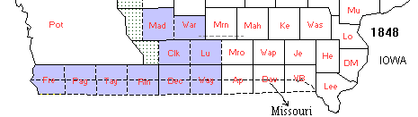
About thirteen miles of the southern border of Iowa, was actually considered in the state of Missouri. The Iowa counties involved would be: Fremont, Page, Taylor, Ringgold, Decatur, Wayne, Appanoose, Davis and Van Buren.
The boundary dispute was finally settled and established between the two states by Dr. William Dewey in 1848, who was commissioned for that purpose.
Information provided by Diane Korten.
If you have any information on the "Honey War" please contact Diane Korten at or us here at .
War Was NEVER So Sweet
by Joel M. Vance
In 1839, Missouri and Iowa mobilized their ragtag militias, ready to start shooting over a tree full of honey.
The bee tree is an artifact of Missouri history. Cutting bee trees for honey once was a food gathering exercise in many rural Missouri households.
Honey turned the lowly biscuit into manna, Biblical sweetbread (manna is described in Exodus as tasting "like wafers made with honey").
In old rural Missouri, there were no cans that burst open to reveal premixed and precut biscuits inside and few farmers kept hives. Some places, flour still was locally ground, but if not, a peddler came down the road every so often in his rickety Model T truck and sold flour in colorful sacks which later became dresses for the girl children.
On a cold winter morning, farm families ate homemade biscuits from the oven of a Warm Morning wood cookstove, slathered with butter churned from the milk of Ol' Sue, and with honey from a bee tree that had been cut down on the branch.
It was a time that will not come again.
Today, there is no incentive to "line" bees (follow them from water or nectar sources to their hive). Domestic honey is plentiful and cheap and environmentalists frown on cutting down a tree to rob its bees.
Honey as a food is as old as recorded history. The Bible is filled with references to honey. In the book of Joshua, as well as in the old folk song about the blue-tailed fly, there's reference to a "land of milk and honey." The Egyptians put hives on barges to transport bees close to flowering fields.
Honey can range from almost inedible to delicately flavored, depending on the source of the nectar the bees carry back to their hive. John Frye, retired assistant chief of Protection for the Conservation Department, has kept bees and tracked wild ones for years. He once found some honey that tasted exactly like bourbon whiskey, but never could find the source.
Wild honey is a hard-won treat, both for humans and for the bees who make it. A researcher once found bees were flying eight miles each way from their hive to an alfalfa field and estimated it took 300,000 miles of travel to produce a pound of honey.
Each bee carried back up to half its own weight in nectar, flying about 15 miles an hour. It's estimated a worker bee will literally work itself to death in six weeks.
Most don't know that honeybees aren't native. They are a European import, certainly one of the few that hasn't proved a pest (like starlings, English sparrows and gypsy moths).
Settlers imported the first honeybees in 1638. Once bees escaped to the forests, they quickly adapted and spread, and by 1820 when Missouri became a state, the wild bee tree was a prize for a settler with a sweet tooth. It also was the reason for the weirdest near-war in the state's history, the abortive Honey War of 1839.
The Honey War today is remembered only by a few historians. It didn't last long and it didn't amount to much, but as wars go it was the best of all possible worlds. It provided entertainment for everyone and no one got hurt.
There's a metal marker on the northeast Missouri farm of Mr. and Mrs. Charles Longnecker. It's about three feet high. Time and the Des Moines River silt are burying it. Mrs. Longnecker's late father, Albert Evans, who rented the farm around World War One, remembered the post as being his height.
Perhaps in another century, the rich dirt will bury the last monument to the silliest war in American history, the Honey War. In 1839, Missouri and Iowa mobilized their ragtag militias, ready to start shooting over who owned a wild river bottom full of bee trees.
The dispute got its name when a Missourian, whose name apparently has been lost by historians, cut three bee trees in an area claimed both by Missouri and Iowa. The trees were valuable both for the honey, which sold for up to $.37 a gallon, and for beeswax, which was used in various ways (the finest candles were of beeswax).
Iowa tried the bee tree thief in absentia and fined him $1.50.
That inflamed Missourians, who have never been reluctant to bash heads over real or imagined wrongs. Missouri had been a state since 1821. Iowa Territory was about to become one, so the legal boundary between the two was an immediate issue.
In 1837, Joseph Brown, a Missouri surveyor, set a boundary line which no one paid much attention to. In 1838, Maj. Albert Lea, a federal surveyor, laid out four possible boundary lines, all representing different interpretations of historical data.
The contested area between Lea's southernmost possibility and the northernmost was about 2,600 square miles, ranging from nine to 11 miles wide from the Des Moines River west to the Missouri River.
Missouri Gov. Lilburn Boggs, a contentious type, proclaimed in August 1839, that Brown's 1837 boundary, the northernmost line, was the state line. Perhaps Boggs was ticked off because the tree cutting Missourian had been fined by Iowa in what Boggs considered Missouri.
Almost immediately, Iowa Gov. Robert Lucas authorized the arrest of anyone trying to exercise authority in what he called "the seat of excitement."
Enter Uriah (Sandy) Gregory, Clark County sheriff from Missouri. He was ordered north into the contested territory to collect taxes on, among other things, bee trees.
Most of the residents in the "seat of excitement" were Iowans by nature and they ordered Sheriff Gregory to go home. He was outnumbered about 1,200 to one, so he prudently went back south of all the possible boundaries.
Plaintively, if ungrammatically, he wrote Gov. Boggs, "I am at a loss what to do the Citizens of that territory two-thirds of which is hostile to the officer and declare if I pretend to use any authority which I am invested by the State of Missouri, they will take me by fourse and put me in confinement."
Gov. Boggs ordered Gregory to go get those taxes. The Iowans weren't kidding. They took the beleaguered sheriff by "fourse" and confined him in Burlington. He later said they treated him pretty well and let him roam around town, but wouldn't let him go home. He apparently enjoyed his enforced vacation and seemed relieved to have his problems solved for him.
It now was December, snowy and bitterly cold. Both sides began to arm for battle. The alarmed Gov. Lucas prophesied, wrongly as it turned out, that the dispute "might ultimately lead to the effusion of blood." He called up 1,200 men who cried, "Death to the Pukes," and drank plenty of whiskey. They were a bit officer heavy. They had four generals, nine general staff officers, 40 field officers and 83 company officers.
The Missourians tried to raise 2,200 militiamen, but less than half showed up. However, they were armed with the latest technology: one carried a sausage stuffer. The mind reels a bit at the thought of the probable effects of an attack with a sausage stuffer.
Meanwhile, Clark County officials, exhibiting rare common sense, sent a delegation to Iowa to work out a truce. The two sides came up with a classic political solution: they dumped the problem in the lap of the federal government and both sides told their soldiers to go home.
The Lewis County, Missouri, militia had spent two nights bivouacked in the cold and snow without tents or enough blankets. They did, however, have plenty of whiskey. One company brought six wagons of provisions and five of them were reputed to be filled with booze.
Even so, they weren't the happiest of campers. They wanted to shoot something. So they split a haunch of venison, labeled one half "Gov. Boggs," the other "Gov. Lucas," shot them full of holes and held a mock funeral.
Then both sides made a rowdy retreat and the Honey War was over. Ultimately, the two states compromised on a state line close to the middle of the four possible boundaries, and in 1850 set markers every 10 miles.
Some have vanished (one showed up in the back yard of a fraternity at Northwest Missouri State College at Maryville), but many still exist. However, the one on the Longnecker farm is the only one to mark the "seat of excitement."
Joel Vance is author of two humor collections: Grandma and the Buck Deer and Confessions of an Outdoor Maladroit.
|